Halfmoon Bay to Secret Cove
Thursday, June 22, 2006
A group of residents led by Elsie Rudland has done a great job of organizing and constructing a set of trails in Halfmoon Bay. The trails are not easy to find but once we found them, we have returned many times to enjoy them. Today we were going to check whether they were still accessible and whether there had been any changes.
We drove off the ferry at Langdale at 8 a.m. and headed up the Sunshine Coast Highway. We followed in convoy as far as Sechelt where the traffic thinned and we were on our own to Halfmoon Bay. We turned left onto Curran Road (the first road past the Halfmoon Bay exit) and bore right onto Jorgensen Road to its end. We found a parking spot that did not inconvenience the residents and then prepared ourselves for the hike.
 This walk has one of the most unexpected starts that I know. We set off along the track that continues from the road's end until we reached a gravel road (this is an access from Brooks Road on the right to two houses on the left). Jogging briefly left and almost immediately right led onto a grassy area. We continued, pushing through bushes on an overgrown path, with only our knowledge that there was a trail at its end to keep us going. Sure enough, an opening on the left led into a wooded area and from here on we could follow signed trails. I understand that the Curran Connection is made available and maintained by the generosity of Mr. Jorgensen.
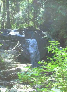
The red-taped trail continues for about five minutes to an intersection at the foot of a valley. A signed Nature Trail leads uphill to a big maple tree and a network of trails which are particularly attractive in the spring. A short road journey from the end of one of these trails leads to Smuggler Cove Provincial Park. However, our journey today took us straight on along the signed Falls Trail. Purple and yellow tapes led us to Brooks Road where a sign on the other side read Falls 25 minutes. We meandered through Sechelt Provincial Forest, the traffic noise from the Sunshine Coast Highway getting gradually louder until we angled away from it and arrived at the falls. We crossed Homesite Creek just below the falls and had a coffee break. This is a pleasant falls when it is flowing gently. In the winter it can be virtually dry and in the spring, the current can be too fast for a safe crossing and you have to detour to the highway and back.
After our break, we set off on the loop trail on the north side, going clockwise. There used to be a yellow-taped trail leading out to the highway, allowing you to walk briefly along it before turning off for Secret Cove. However, we couldn't find it this time; it was probably covered by a fallen tree. So we bushwhacked out at about the right point and then walked down and left onto Sans Souci Road.
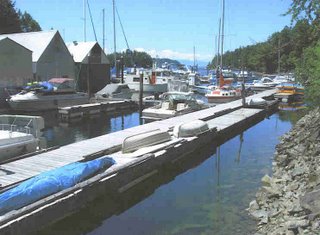
Following down, bending right at the first intersection and then left at the next brings you to Buccaneer Marina. Here we followed the shoreline to the right to the end of the parking lot and then continued, finding a small trail at the bank's edge leading up to a road. This led down to Duke Marina, where we travelled the boardwalk leading to the Jolly Roger. Coming on to land, we went up the hill to the Inn to enjoy a well-earned lunch. Unluckily for us, the door was shut and a notice indicated that the owners had gone fishing for three days, today being the first. So we had to sit on a seat and eat the sandwich lunch we had brought with us.
After our lunches, we went up the hill to Mercer Road and then down the hill into Secret Cove. The upper side of the road is lined with houses on stilts offering their occupantsr views out to sea. At the foot of the hill, we looked into the general store, buying ice creams and picking up various notices of upcoming local activities. Going back up the hill, we followed Mercer road out to the highway and south to Sans Souci Road. Here we crossed into a forest service road and followed it up the hill until a pipeline right-of-way led off to the right. This made a quiet route through the woods to Homesite Forest Road and back down to the highway. A four-minute walk took us to Homesite Creek where a trail on the west side of the highway led along the south side of the creek to Homesite Falls, our coffee stop. We retraced our steps to Brooks Road and because time was running short, we followed Brooks Road to the left until the access road led off right at a corner close to the highway. We followed this access road back to the Curran Connection and to our car. We chatted to some of the residents coming out of their houses and then drove to Langdale with a good five minutes to spare before the ferry left.


Return to Further Walks
We drove off the ferry at Langdale at 8 a.m. and headed up the Sunshine Coast Highway. We followed in convoy as far as Sechelt where the traffic thinned and we were on our own to Halfmoon Bay. We turned left onto Curran Road (the first road past the Halfmoon Bay exit) and bore right onto Jorgensen Road to its end. We found a parking spot that did not inconvenience the residents and then prepared ourselves for the hike.
 This walk has one of the most unexpected starts that I know. We set off along the track that continues from the road's end until we reached a gravel road (this is an access from Brooks Road on the right to two houses on the left). Jogging briefly left and almost immediately right led onto a grassy area. We continued, pushing through bushes on an overgrown path, with only our knowledge that there was a trail at its end to keep us going. Sure enough, an opening on the left led into a wooded area and from here on we could follow signed trails. I understand that the Curran Connection is made available and maintained by the generosity of Mr. Jorgensen.
The red-taped trail continues for about five minutes to an intersection at the foot of a valley. A signed Nature Trail leads uphill to a big maple tree and a network of trails which are particularly attractive in the spring. A short road journey from the end of one of these trails leads to Smuggler Cove Provincial Park. However, our journey today took us straight on along the signed Falls Trail. Purple and yellow tapes led us to Brooks Road where a sign on the other side read Falls 25 minutes. We meandered through Sechelt Provincial Forest, the traffic noise from the Sunshine Coast Highway getting gradually louder until we angled away from it and arrived at the falls. We crossed Homesite Creek just below the falls and had a coffee break. This is a pleasant falls when it is flowing gently. In the winter it can be virtually dry and in the spring, the current can be too fast for a safe crossing and you have to detour to the highway and back.
After our break, we set off on the loop trail on the north side, going clockwise. There used to be a yellow-taped trail leading out to the highway, allowing you to walk briefly along it before turning off for Secret Cove. However, we couldn't find it this time; it was probably covered by a fallen tree. So we bushwhacked out at about the right point and then walked down and left onto Sans Souci Road.
Following down, bending right at the first intersection and then left at the next brings you to Buccaneer Marina. Here we followed the shoreline to the right to the end of the parking lot and then continued, finding a small trail at the bank's edge leading up to a road. This led down to Duke Marina, where we travelled the boardwalk leading to the Jolly Roger. Coming on to land, we went up the hill to the Inn to enjoy a well-earned lunch. Unluckily for us, the door was shut and a notice indicated that the owners had gone fishing for three days, today being the first. So we had to sit on a seat and eat the sandwich lunch we had brought with us.
After our lunches, we went up the hill to Mercer Road and then down the hill into Secret Cove. The upper side of the road is lined with houses on stilts offering their occupantsr views out to sea. At the foot of the hill, we looked into the general store, buying ice creams and picking up various notices of upcoming local activities. Going back up the hill, we followed Mercer road out to the highway and south to Sans Souci Road. Here we crossed into a forest service road and followed it up the hill until a pipeline right-of-way led off to the right. This made a quiet route through the woods to Homesite Forest Road and back down to the highway. A four-minute walk took us to Homesite Creek where a trail on the west side of the highway led along the south side of the creek to Homesite Falls, our coffee stop. We retraced our steps to Brooks Road and because time was running short, we followed Brooks Road to the left until the access road led off right at a corner close to the highway. We followed this access road back to the Curran Connection and to our car. We chatted to some of the residents coming out of their houses and then drove to Langdale with a good five minutes to spare before the ferry left.


Return to Further Walks